IMAGES TAKEN NEAR TO
Tuesley Lane, GODALMING, GU7 1SE
Introduction
This page details the photographs taken nearby to Tuesley Lane, GU7 1SE by members of the Geograph project.
The Geograph project started in 2005 with the aim of publishing, organising and preserving representative images for every square kilometre of Great Britain, Ireland and the Isle of Man.

There are currently over 7.5m images from over14,400 individuals and you can help contribute to the project by visiting https://www.geograph.org.uk
Image Map
Images are licensed for reuse under creativecommons.org/licenses/by-sa/2.0
Notes
- Clicking on the map will re-center to the selected point.
- The higher the marker number, the further away the image location is from the centre of the postcode.
Image Listing (4 Images Found)
Images are licensed for reuse under creativecommons.org/licenses/by-sa/2.0
Image
Details
Distance
1
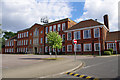
Godalming College
The original Godalming County School building, opened in 1930, has only changed a little. The most obvious change is addition of the telephone antennae.
However, extensive additional building has taken place to the rear and on the sports fields.
The school became Godalming Grammar School. The conversion to a sixth-form college was completed in 1978.
Image: © Ian Taylor
Taken: 17 Jul 2010
0.16 miles
2

Old Boundary Marker on Tuesley lane, Godalming
Estate Boundary Marker on the east side of Tuesley Lane south of the junction with Park Road under vegetation beside an electricity substation. Inscribed A W. Francis Boyd Shannon Wilder owned Busbridge Hall in the 1840's and A W might record a relative. See https://www.andrewsgen.com/photo/godalming/busbridge_hall02.htm.
Milestone Society National ID: SY_GOD04em
Image: © J Hills
Taken: 27 Mar 2021
0.19 miles
3
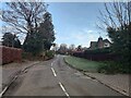
Busbridge Lane
Residential area of Holloway Hill.
Image: © James Emmans
Taken: 23 Jan 2021
0.20 miles