IMAGES TAKEN NEAR TO
Tuesley Lane, GODALMING, GU7 1SB
Introduction
This page details the photographs taken nearby to Tuesley Lane, GU7 1SB by members of the Geograph project.
The Geograph project started in 2005 with the aim of publishing, organising and preserving representative images for every square kilometre of Great Britain, Ireland and the Isle of Man.

There are currently over 7.5m images from over14,400 individuals and you can help contribute to the project by visiting https://www.geograph.org.uk
Image Map
Images are licensed for reuse under creativecommons.org/licenses/by-sa/2.0
Notes
- Clicking on the map will re-center to the selected point.
- The higher the marker number, the further away the image location is from the centre of the postcode.
Image Listing (37 Images Found)
Images are licensed for reuse under creativecommons.org/licenses/by-sa/2.0
Image
Details
Distance
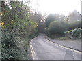
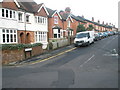
2

Holloway Hill, Godalming, Surrey
A steep descent, towards the town centre.
Image: © Peter Trimming
Taken: 22 May 2012
0.17 miles
3
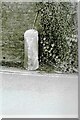
Old Milestone, was on the A3100 (was A3), Ockford Road
The milestone was located on the narrow strip of tarmac between road and stone wall, on the East side of the road, opposite no. 108. Parish of Godalming (Waverley district). Carved stone post, Guildford facets design, erected by the Kingston & Sheetbridge, 1st District trust in the 18th century.
Inscription was unreadable.
The milestone was destroyed by a lorry sometime before 2005. The image was taken before 2001.
Milestone Society National ID: SY_LP32
Image: © Lionel Joseph
Taken: Unknown
0.21 miles
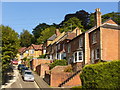
4
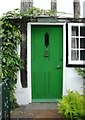
Toad Hall, Ockford Road, Godalming
One of a number of appealing front-doors in a little terrace of cottages. They all stand several feet above the level of the roadway.
Image: © Stefan Czapski
Taken: 26 Aug 2016
0.21 miles
5
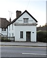
An architectural puzzle - Ockford Road, Godalming
I had driven past this little building a number of times in recent years and had wondered about the curious frieze that runs across the gable end - a detail known as a dentil frieze, normally found as part of a classical façade. Why, I wondered, had a humble little building been graced with such a symbol of social standing?
The road was for centuries a major highway - the old Portsmouth Road - but these days seems fairly narrow for the amount of traffic it carries (notice the double yellow lines). On this August evening I managed to find a place to park, then walked back to have a look. The plate by the door says 'Toll House'. Aha, so the frieze was there as a symbol of authority.
I suspect that an architectural historian like Sir John Summerson would look at the four horizontal projections in the gable and see them as vestigial capitals - implying two short pilasters and two tall ones. (Were the verticals originally painted in, I wonder?). In any case, in Summerson's terms the whole arrangement would be totally 'ungrammatical' - architectural double-Dutch.
Another curious feature of the building is its plan: the 'façade' (such as it is) is aligned with the roadway, but the walls that flank it run back at a skewed angle. It would be good to know more of its history.
Image: © Stefan Czapski
Taken: 26 Aug 2016
0.21 miles
6
Looking from Holloway Hill into Croft Road
Image: © Basher Eyre
Taken: 28 Nov 2009
0.22 miles
7
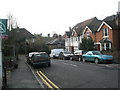
Approaching the junction of Croft Road and Holloway Hill
Image: © Basher Eyre
Taken: 28 Nov 2009
0.22 miles
8
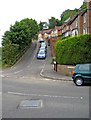
Grove Road
A surprisingly steep residential road.
Image: © P L Chadwick
Taken: 24 Aug 2009
0.22 miles
9
Grove Road, Godalming
Hillside residential road parallel to and above the main road south-west, Ockford Road.
Image: © Colin Smith
Taken: 3 Sep 2010
0.22 miles
10

The Anchor, Godalming
Old pub on the Ockford Road, now modernised inside and with fine landscaped beer garden at the rear.
Image: © Colin Smith
Taken: 3 Sep 2010
0.22 miles