IMAGES TAKEN NEAR TO
Brighton Road, GODALMING, GU7 1NX
Introduction
This page details the photographs taken nearby to Brighton Road, GU7 1NX by members of the Geograph project.
The Geograph project started in 2005 with the aim of publishing, organising and preserving representative images for every square kilometre of Great Britain, Ireland and the Isle of Man.

There are currently over 7.5m images from over14,400 individuals and you can help contribute to the project by visiting https://www.geograph.org.uk
Image Map
Images are licensed for reuse under creativecommons.org/licenses/by-sa/2.0
Notes
- Clicking on the map will re-center to the selected point.
- The higher the marker number, the further away the image location is from the centre of the postcode.
Image Listing (43 Images Found)
Images are licensed for reuse under creativecommons.org/licenses/by-sa/2.0
Image
Details
Distance
1
85 Brighton Road, Crownpits
The former Queen's Head pub, closed in 1951.
Image: © David960
Taken: 3 Jun 2014
0.01 miles
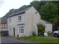
2
Crown House
On the site of the Three Crowns pub in Brighton Road.
Image: © David960
Taken: 3 Jun 2014
0.02 miles
3
Former Busbridge Institute
Grade II listed: http://www.britishlistedbuildings.co.uk/en-291360-2-and-4-crownpits-lane-godalming-surrey
Image: © David960
Taken: 3 Jun 2014
0.03 miles
4
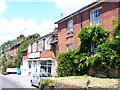
Old and New, Crownpits
New commerce - a tile-hung building with Hunter's Tools sits between modern and Victorian housing on Brighton Road, Godalming.
Image: © Colin Smith
Taken: 27 Jun 2009
0.03 miles
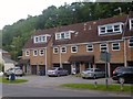
5
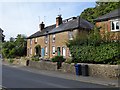
Houses in the Brighton Road, Crownpits, Godalming
At first glance these appear to be brick-built - but the basic building material is local sandstone: Image
Image: © Stefan Czapski
Taken: 1 Sep 2016
0.04 miles
6
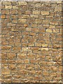
Stone-built house-wall, Brighton Road, Crownpits, Godalming
Detail of the front wall of a house in Brighton Road: http://www.geograph.org.uk/photo/5100688 The stone is plainly local, quarried from one or other level of the Greensand formation.
Image: © Stefan Czapski
Taken: 1 Sep 2016
0.04 miles
7
Crownpits Lane
The street rises up from the Brighton Road which follows the winding valley bottom between Busbridge and Godalming.
Image: © Colin Smith
Taken: 27 Jun 2009
0.07 miles
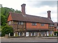
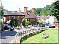
8
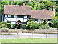
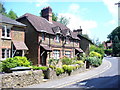
Old Cottages, Crownpits
Two old half-timbered houses, facing onto a green on the Brighton Road, Godalming.
Image: © Colin Smith
Taken: 27 Jun 2009
0.08 miles
9
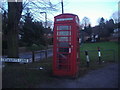
Red phonebox
Old phone box in Godalming.
Image: © David Howard
Taken: 1 Feb 2009
0.09 miles
10
Crownpits
Brighton Road in Crownpits has sharp bends as it ascends the valley to Busbridge. Crownpits gets its name from Old English, crumb, =crooked.
Image: © Colin Smith
Taken: 27 Jun 2009
0.09 miles