IMAGES TAKEN NEAR TO
Woodland Close, GODALMING, GU7 1GE
Introduction
This page details the photographs taken nearby to Woodland Close, GU7 1GE by members of the Geograph project.
The Geograph project started in 2005 with the aim of publishing, organising and preserving representative images for every square kilometre of Great Britain, Ireland and the Isle of Man.

There are currently over 7.5m images from over14,400 individuals and you can help contribute to the project by visiting https://www.geograph.org.uk
Image Map
Images are licensed for reuse under creativecommons.org/licenses/by-sa/2.0
Notes
- Clicking on the map will re-center to the selected point.
- The higher the marker number, the further away the image location is from the centre of the postcode.
Image Listing (79 Images Found)
Images are licensed for reuse under creativecommons.org/licenses/by-sa/2.0
Image
Details
Distance
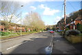

6
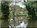
Houses by River Wey
The natural river and the Godalming Navigation part company here, the navigation heading near left on a long cut which includes Catteshall Lock.
Image: © Robin Webster
Taken: 9 Nov 2011
0.10 miles

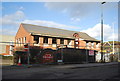
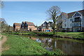
8
New housing, Catteshall
Recently built housing along the bank of the River Wey Navigation in Catteshall near Godalming.
Image: © Alan Hunt
Taken: 22 Aug 2015
0.12 miles
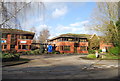
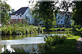
9
Weyside Park, Godalming
New housing near Godalming Wharf at the end of the Wey Navigation.
Image: © Des Blenkinsopp
Taken: 18 Apr 2018
0.12 miles
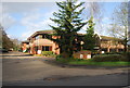
10
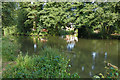
River Wey Navigation, Catteshall
The point at which the navigation cut on the left diverges from the old River Wey. The navigation was created as a series of cuts to take out bends and narrows on the old river channel.
Image: © Alan Hunt
Taken: 22 Aug 2015
0.12 miles