IMAGES TAKEN NEAR TO
Flambard Way, GODALMING, GU7 1FJ
Introduction
This page details the photographs taken nearby to Flambard Way, GU7 1FJ by members of the Geograph project.
The Geograph project started in 2005 with the aim of publishing, organising and preserving representative images for every square kilometre of Great Britain, Ireland and the Isle of Man.

There are currently over 7.5m images from over14,400 individuals and you can help contribute to the project by visiting https://www.geograph.org.uk
Image Map
Images are licensed for reuse under creativecommons.org/licenses/by-sa/2.0
Notes
- Clicking on the map will re-center to the selected point.
- The higher the marker number, the further away the image location is from the centre of the postcode.
Image Listing (384 Images Found)
Images are licensed for reuse under creativecommons.org/licenses/by-sa/2.0
Image
Details
Distance
1
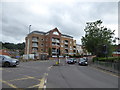
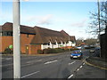
From Westbrook to Sainsbury's (36)
Traffic lights on the A3100
Image: © Basher Eyre
Taken: 27 Jun 2020
0.03 miles
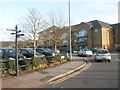
2
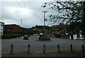
Looking from Waitrose across a roundabout into The Woolsack
Image: © Basher Eyre
Taken: 28 Oct 2021
0.03 miles
5
Junction of Catteshall Lane and Wharf Street
Image: © Basher Eyre
Taken: 28 Nov 2009
0.05 miles
8
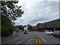
From Westbrook to Sainsbury's (35)
The A3100, looking north-west
Image: © Basher Eyre
Taken: 27 Jun 2020
0.05 miles
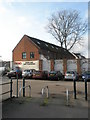
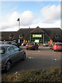
9
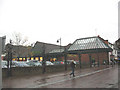
Waitrose, Godalming
A town centre branch of the supermarket chain, rather than an out-of-town one.
Image: © Stephen Craven
Taken: 1 Nov 2008
0.05 miles
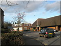
10
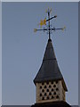
Weathervane in Wharf Street
An earlier submission showing the building beneath is at http://www.geograph.org.uk/photo/1602415.
Image: © Shazz
Taken: 8 Dec 2012
0.06 miles