IMAGES TAKEN NEAR TO
Smithwood Common, CRANLEIGH, GU6 8QS
Introduction
This page details the photographs taken nearby to Smithwood Common, GU6 8QS by members of the Geograph project.
The Geograph project started in 2005 with the aim of publishing, organising and preserving representative images for every square kilometre of Great Britain, Ireland and the Isle of Man.

There are currently over 7.5m images from over14,400 individuals and you can help contribute to the project by visiting https://www.geograph.org.uk
Image Map
Images are licensed for reuse under creativecommons.org/licenses/by-sa/2.0
Notes
- Clicking on the map will re-center to the selected point.
- The higher the marker number, the further away the image location is from the centre of the postcode.
Image Listing (35 Images Found)
Images are licensed for reuse under creativecommons.org/licenses/by-sa/2.0
Image
Details
Distance
4
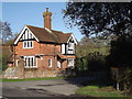
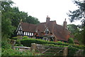
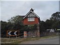
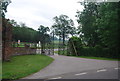
Alderbrook Park Lodge
Red brick house with tile-hung and Mock Tudor features beside an ornate gateway leading into Alderbrook Park.
Image: © Colin Smith
Taken: 27 Jan 2012
0.03 miles
5
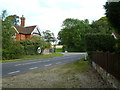
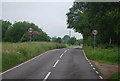
Footpath reaches Smithwood Common Road from the west
The gates over the road are for the access road to Alderbrook Farm.
Image: © Shazz
Taken: 23 Sep 2011
0.03 miles
10
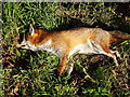
Recumbent Reynard
Roadkill on the grass verge by Alderbrook Farm, Smithwood Common.
Image: © Colin Smith
Taken: 27 Jan 2012
0.06 miles