IMAGES TAKEN NEAR TO
Horseshoe Lane, CRANLEIGH, GU6 8QB
Introduction
This page details the photographs taken nearby to Horseshoe Lane, GU6 8QB by members of the Geograph project.
The Geograph project started in 2005 with the aim of publishing, organising and preserving representative images for every square kilometre of Great Britain, Ireland and the Isle of Man.

There are currently over 7.5m images from over14,400 individuals and you can help contribute to the project by visiting https://www.geograph.org.uk
Image Map
Images are licensed for reuse under creativecommons.org/licenses/by-sa/2.0
Notes
- Clicking on the map will re-center to the selected point.
- The higher the marker number, the further away the image location is from the centre of the postcode.
Image Listing (38 Images Found)
Images are licensed for reuse under creativecommons.org/licenses/by-sa/2.0
Image
Details
Distance
9
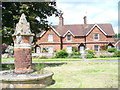
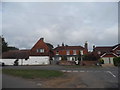
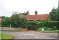
Fountain, Cranleigh Common
Brick fountain at the northern apex of the triangular common. Behind are traditional tile-hung cottages.
Image: © Colin Smith
Taken: 13 Jun 2008
0.10 miles
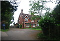
10
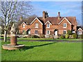
Cranleigh Common
Tile-hung cottages overlook the triangular green at the west end of this village - reputedly England's largest.
Image: © Colin Smith
Taken: 9 Jan 2015
0.10 miles