IMAGES TAKEN NEAR TO
Smithwood Avenue, CRANLEIGH, GU6 8PS
Introduction
This page details the photographs taken nearby to Smithwood Avenue, GU6 8PS by members of the Geograph project.
The Geograph project started in 2005 with the aim of publishing, organising and preserving representative images for every square kilometre of Great Britain, Ireland and the Isle of Man.

There are currently over 7.5m images from over14,400 individuals and you can help contribute to the project by visiting https://www.geograph.org.uk
Image Map
Images are licensed for reuse under creativecommons.org/licenses/by-sa/2.0
Notes
- Clicking on the map will re-center to the selected point.
- The higher the marker number, the further away the image location is from the centre of the postcode.
Image Listing (34 Images Found)
Images are licensed for reuse under creativecommons.org/licenses/by-sa/2.0
Image
Details
Distance
1
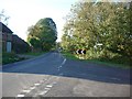
Junction of Alderbrook Road with Smithwood Common Road
looking west
Image: © Andrew Longton
Taken: 27 Oct 2005
0.13 miles
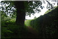
6
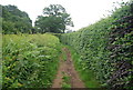
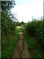
Footpath on the edge of Smithwood Common
Image: © N Chadwick
Taken: 10 Jun 2012
0.15 miles
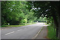
8
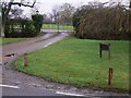
Gates to Smithwood House on Smithwood Common Road
Image: © Shazz
Taken: 11 Feb 2011
0.16 miles
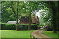
10
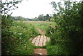
Smithwood Barn
Old farm buildings by the Smithwood Common Road. Image gives a wider view.
Image: © Stefan Czapski
Taken: 22 Mar 2015
0.17 miles