IMAGES TAKEN NEAR TO
Elmbridge Road, CRANLEIGH, GU6 8LP
Introduction
This page details the photographs taken nearby to Elmbridge Road, GU6 8LP by members of the Geograph project.
The Geograph project started in 2005 with the aim of publishing, organising and preserving representative images for every square kilometre of Great Britain, Ireland and the Isle of Man.

There are currently over 7.5m images from over14,400 individuals and you can help contribute to the project by visiting https://www.geograph.org.uk
Image Map
Images are licensed for reuse under creativecommons.org/licenses/by-sa/2.0
Notes
- Clicking on the map will re-center to the selected point.
- The higher the marker number, the further away the image location is from the centre of the postcode.
Image Listing (23 Images Found)
Images are licensed for reuse under creativecommons.org/licenses/by-sa/2.0
Image
Details
Distance
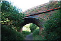
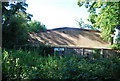
5
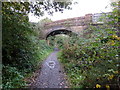
The B2130 road bridge over the dismantled Horsham to Guildford line
Now the Downs Link path.
Image: © Dave Spicer
Taken: 5 Nov 2011
0.07 miles
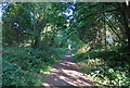
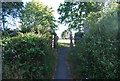
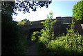
6
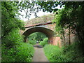
Downs Link, near Cranleigh
The Downs Link path follows a dismantled railway line for most of its length. It also forms part of route 223 of the National Cycle Network.
Here, a bridge carries a 'B' road over the former railway line.
Image: © Malc McDonald
Taken: 3 Jun 2022
0.07 miles