IMAGES TAKEN NEAR TO
Rosemary Lane, CRANLEIGH, GU6 8EY
Introduction
This page details the photographs taken nearby to Rosemary Lane, GU6 8EY by members of the Geograph project.
The Geograph project started in 2005 with the aim of publishing, organising and preserving representative images for every square kilometre of Great Britain, Ireland and the Isle of Man.

There are currently over 7.5m images from over14,400 individuals and you can help contribute to the project by visiting https://www.geograph.org.uk
Image Map
Images are licensed for reuse under creativecommons.org/licenses/by-sa/2.0
Notes
- Clicking on the map will re-center to the selected point.
- The higher the marker number, the further away the image location is from the centre of the postcode.
Image Listing (7 Images Found)
Images are licensed for reuse under creativecommons.org/licenses/by-sa/2.0
Image
Details
Distance
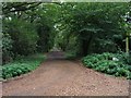
1
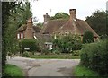
Sachel Hill Lane
Seen from Rosemary Lane, opposite Image
Image: © Andy Potter
Taken: 28 Sep 2006
0.05 miles
2
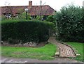
Winding garden path to Rosemary Cottage
Image: © Andy Potter
Taken: 28 Sep 2006
0.07 miles
3
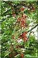
Black Bryony berries in Rosemary Lane
I think this is the Black Bryony (Tamus communis)
found opposite Image
Image: © Andy Potter
Taken: 28 Sep 2006
0.07 miles
5
Velhurst Gate
On Rosemary Lane, at the bottom of the drive to Velhurst Farm.
Image: © Andy Potter
Taken: 28 Sep 2006
0.19 miles
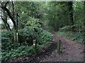
6
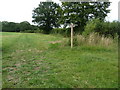
New waymarker at footpath and bridleway junction
An eastern edge of Westland Copse is in the background.
Image: © Dave Spicer
Taken: 17 Jul 2011
0.23 miles
7
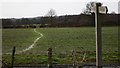
Signpost at county boundary
This signpost has been erected by West Sussex County Council. The field ahead is in West Sussex but the camera is in Surrey.
Image: © Shazz
Taken: 24 Jan 2009
0.25 miles