IMAGES TAKEN NEAR TO
Horsham Road, CRANLEIGH, GU6 8EH
Introduction
This page details the photographs taken nearby to Horsham Road, GU6 8EH by members of the Geograph project.
The Geograph project started in 2005 with the aim of publishing, organising and preserving representative images for every square kilometre of Great Britain, Ireland and the Isle of Man.

There are currently over 7.5m images from over14,400 individuals and you can help contribute to the project by visiting https://www.geograph.org.uk
Image Map
Images are licensed for reuse under creativecommons.org/licenses/by-sa/2.0
Notes
- Clicking on the map will re-center to the selected point.
- The higher the marker number, the further away the image location is from the centre of the postcode.
Image Listing (16 Images Found)
Images are licensed for reuse under creativecommons.org/licenses/by-sa/2.0
Image
Details
Distance
2
B2128 Horsham Road out of Cranleigh, SE to Longhurst Hill
Image: © Dave Spicer
Taken: 4 Dec 2011
0.14 miles
3
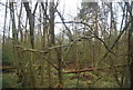
Bridleway at Longhurst Hill
The bridleway leaving the Horsham Road and heading along the ridgeway at Longhurst Hill.
Image: © Chris Thomas-Atkin
Taken: 14 Apr 2019
0.16 miles
5
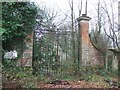
Disused Entrance to Baynard's Park Estate
Image: © Martyn Davies
Taken: 13 Jan 2007
0.17 miles
6
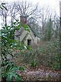
Disused Gatehouse at Baynard's Park Estate
Part of the no longer-used entrance (see Image) to the estate.
Image: © Martyn Davies
Taken: 13 Jan 2007
0.17 miles
7

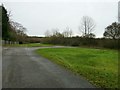
Entrance to private road on Longhurst Hill
This leads to various parks and Baynard's Park
Image: © David Howard
Taken: 13 Sep 2015
0.17 miles
8
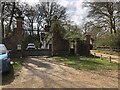
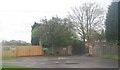
Gateway to Baynards Park
The north west gateway at Longhurst Hill leading to Baynards Park. The gateway and walls are a Grade II listed building, as is the lodge just behind the gates. The gateway was disused for sometime and renovated around 2012.
For an earlier view see Image
Image: © Chris Thomas-Atkin
Taken: 14 Apr 2019
0.18 miles
9
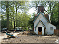
Lodge to Baynard's Park
A grade II listed building, built in 1850s, disused and closed up when listed in 1989. Here, it appears to be being overhauled and possibly extended.
Image: © Robin Webster
Taken: 22 Apr 2011
0.19 miles
10
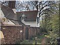
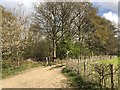
The Lodge
The Lodge at the north west entrance to Baynards Park viewed from the passing bridleway.
Image: © Chris Thomas-Atkin
Taken: 14 Apr 2019
0.19 miles