IMAGES TAKEN NEAR TO
Ashtrees, CRANLEIGH, GU6 8DD
Introduction
This page details the photographs taken nearby to Ashtrees, GU6 8DD by members of the Geograph project.
The Geograph project started in 2005 with the aim of publishing, organising and preserving representative images for every square kilometre of Great Britain, Ireland and the Isle of Man.

There are currently over 7.5m images from over14,400 individuals and you can help contribute to the project by visiting https://www.geograph.org.uk
Image Map
Images are licensed for reuse under creativecommons.org/licenses/by-sa/2.0
Notes
- Clicking on the map will re-center to the selected point.
- The higher the marker number, the further away the image location is from the centre of the postcode.
Image Listing (19 Images Found)
Images are licensed for reuse under creativecommons.org/licenses/by-sa/2.0
Image
Details
Distance
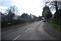
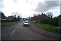
2
Junction of Avenue and Horsham Roads in Cranleigh
Image: © Shazz
Taken: 29 Aug 2011
0.07 miles
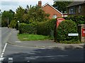
3
Junction of Brookside and Waverleigh Road in Cranleigh
Image: © Shazz
Taken: 29 Aug 2011
0.11 miles
4
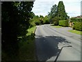
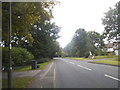
Bend on Horsham Road in Cranleigh
This is the B2128.
Image: © Shazz
Taken: 29 Aug 2011
0.12 miles
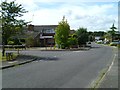
10
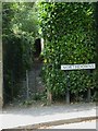
Twitten off Northdowns in Cranleigh
This leads to the Downs Link which is a bridleway along a dismantled railway line.
Image: © Shazz
Taken: 29 Aug 2011
0.23 miles