IMAGES TAKEN NEAR TO
The Street, CRANLEIGH, GU6 7QD
Introduction
This page details the photographs taken nearby to The Street, GU6 7QD by members of the Geograph project.
The Geograph project started in 2005 with the aim of publishing, organising and preserving representative images for every square kilometre of Great Britain, Ireland and the Isle of Man.

There are currently over 7.5m images from over14,400 individuals and you can help contribute to the project by visiting https://www.geograph.org.uk
Image Map (Loading...)


Getting Data...Please wait
Leaflet Map data © OpenStreetMap
Images are licensed for reuse under creativecommons.org/licenses/by-sa/2.0
Notes
- Clicking on the map will re-center to the selected point.
- The higher the marker number, the further away the image location is from the centre of the postcode.
Image Listing (114 Images Found)
Images are licensed for reuse under creativecommons.org/licenses/by-sa/2.0
Image
Details
Distance
1
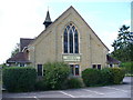
Ewhurst Baptist Church
Stone building on the west side of The Street.
Image: © Colin Smith
Taken: 25 Aug 2007
0.02 miles
4

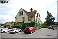
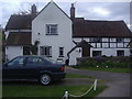
The Bulls Head, Ewhurst
A large pub on the corner of Ockley Road and The Street.
Image: © Jonathan Billinger
Taken: 19 Jun 2008
0.03 miles
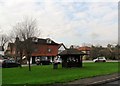
6

The Bulls Head - from across The Street
Situated at the north end of the village of Ewhurst.
Image: © Jonathan Billinger
Taken: 19 Jun 2008
0.03 miles