IMAGES TAKEN NEAR TO
Barhatch Lane, CRANLEIGH, GU6 7NH
Introduction
This page details the photographs taken nearby to Barhatch Lane, GU6 7NH by members of the Geograph project.
The Geograph project started in 2005 with the aim of publishing, organising and preserving representative images for every square kilometre of Great Britain, Ireland and the Isle of Man.

There are currently over 7.5m images from over14,400 individuals and you can help contribute to the project by visiting https://www.geograph.org.uk
Image Map
Images are licensed for reuse under creativecommons.org/licenses/by-sa/2.0
Notes
- Clicking on the map will re-center to the selected point.
- The higher the marker number, the further away the image location is from the centre of the postcode.
Image Listing (22 Images Found)
Images are licensed for reuse under creativecommons.org/licenses/by-sa/2.0
Image
Details
Distance
2
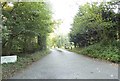
The entrance to Winterfold House on Barhatch Road
Image: © David Howard
Taken: 14 Sep 2014
0.15 miles
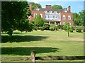
3
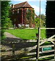
Fowls Copse
Impressive and large country house in the Surrey Weald near Ewhurst.
Image: © Colin Smith
Taken: 28 Mar 2010
0.19 miles
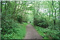
4
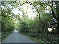
Barhatch Road north of Cranleigh
Going through Winterfold Wood
Image: © David Howard
Taken: 14 Sep 2014
0.20 miles
5
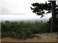
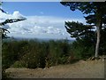
View from Justice James Seat
Not a very clear view on this occasion.
Image: © don cload
Taken: 23 Sep 2009
0.21 miles
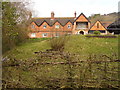
7
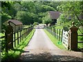
The entrance to Winterfold Farm
from bridleway 358
Image: © Andrew Longton
Taken: 6 Jun 2006
0.22 miles
8
The viewpoint on Reynards Hill
In the centre of the skyline is Blackdown, the summit of which is in West Sussex.
Image: © Shazz
Taken: 19 Sep 2011
0.23 miles