IMAGES TAKEN NEAR TO
Parklands Drive, CRANLEIGH, GU6 7GF
Introduction
This page details the photographs taken nearby to Parklands Drive, GU6 7GF by members of the Geograph project.
The Geograph project started in 2005 with the aim of publishing, organising and preserving representative images for every square kilometre of Great Britain, Ireland and the Isle of Man.

There are currently over 7.5m images from over14,400 individuals and you can help contribute to the project by visiting https://www.geograph.org.uk
Image Map
Images are licensed for reuse under creativecommons.org/licenses/by-sa/2.0
Notes
- Clicking on the map will re-center to the selected point.
- The higher the marker number, the further away the image location is from the centre of the postcode.
Image Listing (13 Images Found)
Images are licensed for reuse under creativecommons.org/licenses/by-sa/2.0
Image
Details
Distance
1
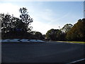
New roundabout on Bookhurst Road, Cranleigh
Even the OS map here has not caught up, although construction for the new road began in 2009, the roundabout being for a new housing estate accessed on the left, while remaking the B road slightly south to construct the new junction here.
Image: © David Howard
Taken: 14 Sep 2014
0.04 miles
2
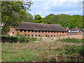
Swallow's Tiles, Cranleigh
This disused brickworks is now under local discussion. It is being proposed that clay is once again to be extracted in Book Hurst - with resultant lorry traffic.
Image: © Colin Smith
Taken: 15 May 2010
0.14 miles
3
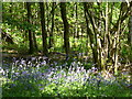
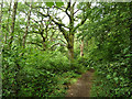
Book Hurst
Coppicing and bluebells in the deciduous woodland east of Cranleigh.
Image: © Colin Smith
Taken: 15 May 2010
0.16 miles
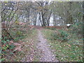
5
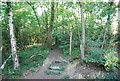
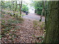
In Book Hurst
Cranleigh footpath 368 threads its way through the woods.
Image: © Robin Webster
Taken: 9 Jun 2011
0.19 miles
6
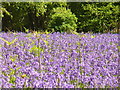
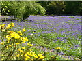
Bluebells, Book Hurst
Colourful carpet of spring flowers - with new bracken growth beginning to show.
Image: © Colin Smith
Taken: 15 May 2010
0.22 miles
8
Bluebells in Book Hurst
Colourful clearing in the May sunshine, east of Cranleigh.
Image: © Colin Smith
Taken: 15 May 2010
0.22 miles
9
Footpath and bridleway intersection
At the western edge of Book Hurst.
Image: © Dave Spicer
Taken: 20 Nov 2011
0.22 miles
10
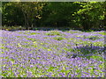
Clearing in Book Hurst
Large open space, carpeted by bluebells, in the deciduous woodland east of cranleigh. Gorse in the foreground.
Image: © Colin Smith
Taken: 15 May 2010
0.22 miles