IMAGES TAKEN NEAR TO
Towerhill, GUILDFORD, GU5 9LP
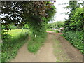
Introduction
This page details the photographs taken nearby to Towerhill, GU5 9LP by members of the Geograph project.
The Geograph project started in 2005 with the aim of publishing, organising and preserving representative images for every square kilometre of Great Britain, Ireland and the Isle of Man.

There are currently over 7.5m images from over14,400 individuals and you can help contribute to the project by visiting https://www.geograph.org.uk
Image Map
Images are licensed for reuse under creativecommons.org/licenses/by-sa/2.0
Notes
- Clicking on the map will re-center to the selected point.
- The higher the marker number, the further away the image location is from the centre of the postcode.
Image Listing (122 Images Found)
Images are licensed for reuse under creativecommons.org/licenses/by-sa/2.0
Image
Details
Distance
1
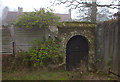
Door near Towerhill farm
The door on the footpath close to the railway bridge and road into Gomshall
Image: © Robert Eva
Taken: 6 Dec 2016
0.02 miles
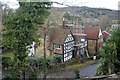
2
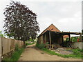
Towerhill Farm, Gomshall
The track passing through the farm is a public right of way as a bridleway. It forms part of route 22 of the National Cycle Network.
Image: © Malc McDonald
Taken: 3 Jun 2022
0.04 miles
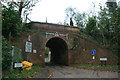
4
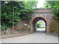
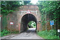
Railway bridge at Gomshall
An arch bridge carries the North Downs Line over a narrow lane in Gomshall.
Route 22 of the National Cycle Network passes through the arch.
Image: © Malc McDonald
Taken: 3 Jun 2022
0.05 miles
5
Bridleway and farm track at Gomshall
The path to the left is a public bridleway which is on route 22 of the National Cycle Network. To the right is a farm track.
Image: © Malc McDonald
Taken: 3 Jun 2022
0.05 miles
6
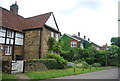
Malthouse Cottages
Grade II listed. http://www.britishlistedbuildings.co.uk/en-288473-malthouse-cottages-maltings-cottages-she
Image: © N Chadwick
Taken: 10 Jun 2012
0.06 miles
10
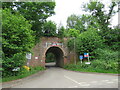
Railway bridge at Gomshall
An arch bridge carries the North Downs Line over a narrow lane in Gomshall. The sign indicates the maximum height for vehicles passing beneath the bridge is 10 feet 3 inches.
Route 22 of the National Cycle Network passes through the arch.
Image: © Malc McDonald
Taken: 3 Jun 2022
0.06 miles