IMAGES TAKEN NEAR TO
Gomshall Lane, GUILDFORD, GU5 9JT
Introduction
This page details the photographs taken nearby to Gomshall Lane, GU5 9JT by members of the Geograph project.
The Geograph project started in 2005 with the aim of publishing, organising and preserving representative images for every square kilometre of Great Britain, Ireland and the Isle of Man.

There are currently over 7.5m images from over14,400 individuals and you can help contribute to the project by visiting https://www.geograph.org.uk
Image Map
Images are licensed for reuse under creativecommons.org/licenses/by-sa/2.0
Notes
- Clicking on the map will re-center to the selected point.
- The higher the marker number, the further away the image location is from the centre of the postcode.
Image Listing (37 Images Found)
Images are licensed for reuse under creativecommons.org/licenses/by-sa/2.0
Image
Details
Distance
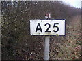
2
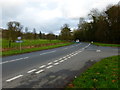
The A25 looking east over the junction with Gomshall Lane
Image: © Shazz
Taken: 25 Feb 2014
0.07 miles
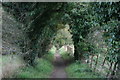
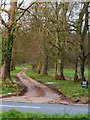
3
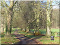
Private Road
Tree-lined driveway leading from Shere to Netley House on the scarp slope of the North Downs.
Image: © Colin Smith
Taken: 6 Dec 2009
0.12 miles
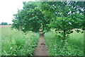
5
The drive to Netley House
The road is the A25.
Image: © Shazz
Taken: 25 Feb 2014
0.13 miles