IMAGES TAKEN NEAR TO
Lower Street, GUILDFORD, GU5 9HT
Introduction
This page details the photographs taken nearby to Lower Street, GU5 9HT by members of the Geograph project.
The Geograph project started in 2005 with the aim of publishing, organising and preserving representative images for every square kilometre of Great Britain, Ireland and the Isle of Man.

There are currently over 7.5m images from over14,400 individuals and you can help contribute to the project by visiting https://www.geograph.org.uk
Image Map
Images are licensed for reuse under creativecommons.org/licenses/by-sa/2.0
Notes
- Clicking on the map will re-center to the selected point.
- The higher the marker number, the further away the image location is from the centre of the postcode.
Image Listing (375 Images Found)
Images are licensed for reuse under creativecommons.org/licenses/by-sa/2.0
Image
Details
Distance
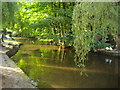
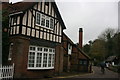
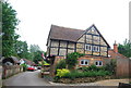
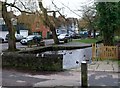
2
Shere - Lower Street
Historic timber-framed and jettied house beside the Tilling Bourne.
Image: © Colin Smith
Taken: 30 Jun 2015
0.01 miles
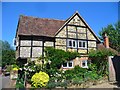
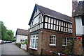
6
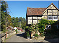
Lower Street, Shere
Old housing beside the Tillingbourne.
Image: © Des Blenkinsopp
Taken: 19 Sep 2019
0.01 miles
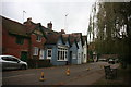
10
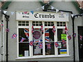
Shere - Crumbs
The village bread shop's window carried a display of Union flags commemorating the Queen's Platinum Jubilee (1952-2022) and a Ukraine flag to support that country as it was being invaded by Russia.
Image: © Colin Smith
Taken: 3 Jun 2022
0.02 miles