IMAGES TAKEN NEAR TO
Humphrey Park, FLEET, GU52 8UD
Introduction
This page details the photographs taken nearby to Humphrey Park, GU52 8UD by members of the Geograph project.
The Geograph project started in 2005 with the aim of publishing, organising and preserving representative images for every square kilometre of Great Britain, Ireland and the Isle of Man.

There are currently over 7.5m images from over14,400 individuals and you can help contribute to the project by visiting https://www.geograph.org.uk
Image Map
Images are licensed for reuse under creativecommons.org/licenses/by-sa/2.0
Notes
- Clicking on the map will re-center to the selected point.
- The higher the marker number, the further away the image location is from the centre of the postcode.
Image Listing (56 Images Found)
Images are licensed for reuse under creativecommons.org/licenses/by-sa/2.0
Image
Details
Distance
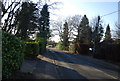
1

Junction of Gables and Aldershot Roads
An earlier view is at http://www.geograph.org.uk/photo/2890030.
Image: © Shazz
Taken: 21 Mar 2014
0.07 miles
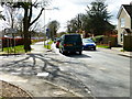
2
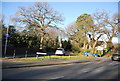
Gables Rd
No entry to this road from this direction.
Image: © N Chadwick
Taken: 15 Jan 2012
0.07 miles
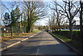
3
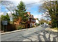
Aldershot Road looking north from Ewshot Lane
Image: © Shazz
Taken: 21 Mar 2014
0.08 miles
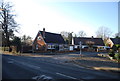

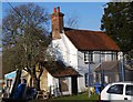
8
Looking south from Aldershot Road at the junction with Ewshot Lane
Image: © Shazz
Taken: 21 Mar 2014
0.11 miles
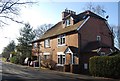
9
Ye Olde Horns
An ex alehouse, Grade II listed. http://www.britishlistedbuildings.co.uk/en-475076-the-old-horns-crookham-village
Image: © N Chadwick
Taken: 15 Jan 2012
0.12 miles