IMAGES TAKEN NEAR TO
Wakefords Copse, FLEET, GU52 8DP
Introduction
This page details the photographs taken nearby to Wakefords Copse, GU52 8DP by members of the Geograph project.
The Geograph project started in 2005 with the aim of publishing, organising and preserving representative images for every square kilometre of Great Britain, Ireland and the Isle of Man.

There are currently over 7.5m images from over14,400 individuals and you can help contribute to the project by visiting https://www.geograph.org.uk
Image Map
Images are licensed for reuse under creativecommons.org/licenses/by-sa/2.0
Notes
- Clicking on the map will re-center to the selected point.
- The higher the marker number, the further away the image location is from the centre of the postcode.
Image Listing (10 Images Found)
Images are licensed for reuse under creativecommons.org/licenses/by-sa/2.0
Image
Details
Distance
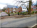
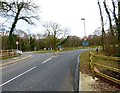
2
The west end of Leipzig Road
I don't know the name of the road at the end.
Image: © Shazz
Taken: 7 Mar 2014
0.13 miles
5
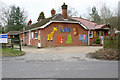
Church Crookham, Hampshire
Woodlands Day Care Centre on the south side of the village.
Image: © Brendan and Ruth McCartney
Taken: 27 Jan 2011
0.14 miles
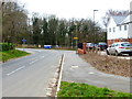
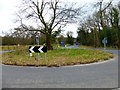
6
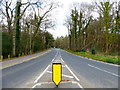
Beacon Hill Road going towards Church Crookham
This was taken from the roundabout at Leipzig Road.
Image: © Shazz
Taken: 7 Mar 2014
0.14 miles
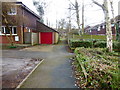
7
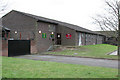
Church Crookham, Hampshire
Army Cadet HQ in the southeast corner of the square.
Image: © Brendan and Ruth McCartney
Taken: 27 Jan 2011
0.16 miles
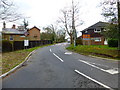
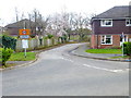
10
Looking south on Beacon Hill Road from the roundabout at Leipzig Road
Image: © Shazz
Taken: 7 Mar 2014
0.23 miles