IMAGES TAKEN NEAR TO
Firethorn Close, FLEET, GU52 7TY
Introduction
This page details the photographs taken nearby to Firethorn Close, GU52 7TY by members of the Geograph project.
The Geograph project started in 2005 with the aim of publishing, organising and preserving representative images for every square kilometre of Great Britain, Ireland and the Isle of Man.

There are currently over 7.5m images from over14,400 individuals and you can help contribute to the project by visiting https://www.geograph.org.uk
Image Map
Images are licensed for reuse under creativecommons.org/licenses/by-sa/2.0
Notes
- Clicking on the map will re-center to the selected point.
- The higher the marker number, the further away the image location is from the centre of the postcode.
Image Listing (7 Images Found)
Images are licensed for reuse under creativecommons.org/licenses/by-sa/2.0
Image
Details
Distance
2
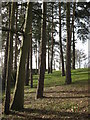
Small area of woodland at Longmead
This is the only remaining area of mature trees beside Longmead road.
Image: © don cload
Taken: 31 Jan 2010
0.11 miles
3
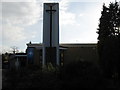
Fleet Methodist Church
The new Fleet Methodist Church was officially opened and dedicated on July 22nd 1972 to a congregation of 500. The Service was followed by a 24 hour prayer vigil. The Church which had cost £50,000 to build was opened free of any debt! http://www.fleetmethodist.org.uk/history.html
Image: © Richard Rogerson
Taken: 4 Apr 2010
0.22 miles
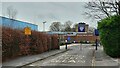
4
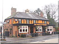
Fleet - The Prince of Wales
This large pub on Reading Road South has recently undergone a makeover.
http://en.wikipedia.org/wiki/Fleet,_Hampshire
Image: © Colin Smith
Taken: 9 Mar 2013
0.23 miles
5
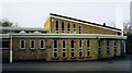
Fleet Methodist Church
Modern building built in 1972.
Image: © Michael FORD
Taken: Unknown
0.23 miles
6

NEW
The Prince of Wales, Fleet
A change of colour from twelve years ago Image
Image: © Richard Rogerson
Taken: 5 Mar 2025
0.23 miles