IMAGES TAKEN NEAR TO
Denning Close, FLEET, GU52 7SP
Introduction
This page details the photographs taken nearby to Denning Close, GU52 7SP by members of the Geograph project.
The Geograph project started in 2005 with the aim of publishing, organising and preserving representative images for every square kilometre of Great Britain, Ireland and the Isle of Man.

There are currently over 7.5m images from over14,400 individuals and you can help contribute to the project by visiting https://www.geograph.org.uk
Image Map
Images are licensed for reuse under creativecommons.org/licenses/by-sa/2.0
Notes
- Clicking on the map will re-center to the selected point.
- The higher the marker number, the further away the image location is from the centre of the postcode.
Image Listing (43 Images Found)
Images are licensed for reuse under creativecommons.org/licenses/by-sa/2.0
Image
Details
Distance

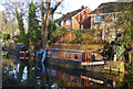
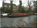
2
A cheerful, short narrow boat
Basingstoke canal.
Image: © Fernweh
Taken: 6 Feb 2012
0.04 miles
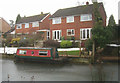
3
Cold conditions by the canal
The Basingstoke canal.
Image: © Fernweh
Taken: 6 Feb 2012
0.05 miles
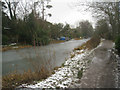
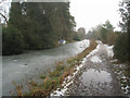
5
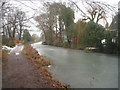
Basingstoke canal towpath
View just south of Fleet.
Image: © Fernweh
Taken: 6 Feb 2012
0.06 miles
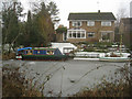
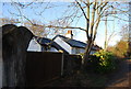
6
Canal side property - Fleet
Basingstoke canal.
Image: © Fernweh
Taken: 6 Feb 2012
0.06 miles
9
Wet going along the towpath
Basingstoke canal close to the Crookham Road.
Image: © Fernweh
Taken: 6 Feb 2012
0.06 miles