IMAGES TAKEN NEAR TO
Dinorben Avenue, FLEET, GU52 7SG
Introduction
This page details the photographs taken nearby to Dinorben Avenue, GU52 7SG by members of the Geograph project.
The Geograph project started in 2005 with the aim of publishing, organising and preserving representative images for every square kilometre of Great Britain, Ireland and the Isle of Man.

There are currently over 7.5m images from over14,400 individuals and you can help contribute to the project by visiting https://www.geograph.org.uk
Image Map
Images are licensed for reuse under creativecommons.org/licenses/by-sa/2.0
Notes
- Clicking on the map will re-center to the selected point.
- The higher the marker number, the further away the image location is from the centre of the postcode.
Image Listing (89 Images Found)
Images are licensed for reuse under creativecommons.org/licenses/by-sa/2.0
Image
Details
Distance
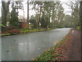
4
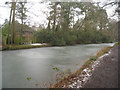
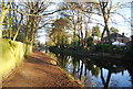
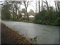
Basingstoke canal - Fleet
Not quite like the frozen canals of Amsterdam. (There was a very cold snap across Europe when photo taken).
Image: © Fernweh
Taken: 6 Feb 2012
0.06 miles
5

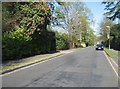
Bridge carrying Reading Road South over the Basingstoke Canal
Image: © Katherine Rusbridge
Taken: 7 Nov 2008
0.06 miles
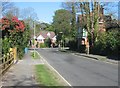
6
Basingstoke canal - Fleet
The houses opposite the tow path are in Dinorben Avenue. As you can imagine if your road is called 'Avenue' the houses must be large! and these are.
Image: © Fernweh
Taken: 6 Feb 2012
0.07 miles