IMAGES TAKEN NEAR TO
Ferndale Road, FLEET, GU52 6LP
Introduction
This page details the photographs taken nearby to Ferndale Road, GU52 6LP by members of the Geograph project.
The Geograph project started in 2005 with the aim of publishing, organising and preserving representative images for every square kilometre of Great Britain, Ireland and the Isle of Man.

There are currently over 7.5m images from over14,400 individuals and you can help contribute to the project by visiting https://www.geograph.org.uk
Image Map
Images are licensed for reuse under creativecommons.org/licenses/by-sa/2.0
Notes
- Clicking on the map will re-center to the selected point.
- The higher the marker number, the further away the image location is from the centre of the postcode.
Image Listing (6 Images Found)
Images are licensed for reuse under creativecommons.org/licenses/by-sa/2.0
Image
Details
Distance
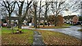
1
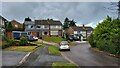
Park Hill road loop
A complex maze of small residential roads avoids through traffic and improves security.
Image: © James Emmans
Taken: 13 Dec 2021
0.13 miles
2
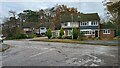
Road junction of Park Hill and Portland Drive
Semi-detached housing in Church Cookham, Fleet.
Image: © James Emmans
Taken: 13 Dec 2021
0.18 miles
3
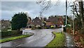
Portland Drive junction with Chesilton Crescent
Image: © James Emmans
Taken: 13 Dec 2021
0.19 miles
4
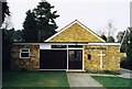
Church Crookham Baptist Church
Built in 1957.
Image: © Michael FORD
Taken: Unknown
0.22 miles
5
Pipers Croft
Short dead end road with turning circle.
Image: © James Emmans
Taken: 13 Dec 2021
0.22 miles
6
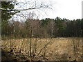
Open Space between Fleet and Church Crookham
This area between Fleet and Church Crookham, stated to be an Open Space on the signboards, comprises mainly mature woodland. No other name for this area found on any sign.
Image: © don cload
Taken: 31 Jan 2010
0.24 miles