IMAGES TAKEN NEAR TO
Northfield Road, FLEET, GU52 6ED
Introduction
This page details the photographs taken nearby to Northfield Road, GU52 6ED by members of the Geograph project.
The Geograph project started in 2005 with the aim of publishing, organising and preserving representative images for every square kilometre of Great Britain, Ireland and the Isle of Man.

There are currently over 7.5m images from over14,400 individuals and you can help contribute to the project by visiting https://www.geograph.org.uk
Image Map
Images are licensed for reuse under creativecommons.org/licenses/by-sa/2.0
Notes
- Clicking on the map will re-center to the selected point.
- The higher the marker number, the further away the image location is from the centre of the postcode.
Image Listing (13 Images Found)
Images are licensed for reuse under creativecommons.org/licenses/by-sa/2.0
Image
Details
Distance
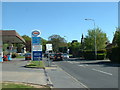
2
Looking into Potters Industrial Park from Coxmoor Close
Image: © Shazz
Taken: 7 Mar 2014
0.09 miles
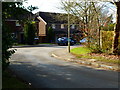
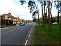
3
Looking west along Aldershot Road from Coxmoor Close
Image: © Shazz
Taken: 7 Mar 2014
0.13 miles
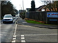
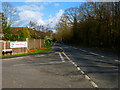
4
Supply stop, Church Crookham
On the B3013.
Image: © David Medcalf
Taken: 5 May 2006
0.16 miles
5
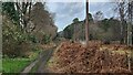
Power lines next to Forest of Eversley
Footpath close to Church Cookham
Image: © James Emmans
Taken: 3 Jan 2022
0.17 miles
6
Looking east along Aldershot Road from Coxmoor Close
Image: © Shazz
Taken: 7 Mar 2014
0.18 miles
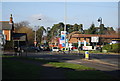
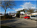
8
Roundabout on Beacon Hill Road, Church Crookham
Image: © David Howard
Taken: 14 Aug 2016
0.20 miles
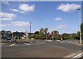
9
Looking east on Aldershot Road towards the roundabout with the B3013
Image: © Shazz
Taken: 7 Mar 2014
0.21 miles