IMAGES TAKEN NEAR TO
Netherhouse Moor, FLEET, GU51 5TS
Introduction
This page details the photographs taken nearby to Netherhouse Moor, GU51 5TS by members of the Geograph project.
The Geograph project started in 2005 with the aim of publishing, organising and preserving representative images for every square kilometre of Great Britain, Ireland and the Isle of Man.

There are currently over 7.5m images from over14,400 individuals and you can help contribute to the project by visiting https://www.geograph.org.uk
Image Map
Images are licensed for reuse under creativecommons.org/licenses/by-sa/2.0
Notes
- Clicking on the map will re-center to the selected point.
- The higher the marker number, the further away the image location is from the centre of the postcode.
Image Listing (12 Images Found)
Images are licensed for reuse under creativecommons.org/licenses/by-sa/2.0
Image
Details
Distance
1
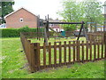
Child's Play
Playground at the edge of the sprawling residential area of Church Crookham which is now part of Fleet.
Image: © Colin Smith
Taken: 8 May 2011
0.19 miles
2
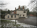
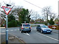
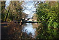
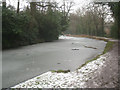
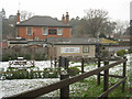
Fox & Hounds pub
A prime location by the Basingstoke canal for summer traffic.
Image: © Fernweh
Taken: 6 Feb 2012
0.21 miles
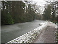
5
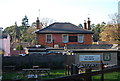
Pub garden (Fox & Hounds)
As seen from the canal towpath.
Image: © Fernweh
Taken: 6 Feb 2012
0.22 miles