IMAGES TAKEN NEAR TO
Hitches Lane, FLEET, GU51 5JA
Introduction
This page details the photographs taken nearby to Hitches Lane, GU51 5JA by members of the Geograph project.
The Geograph project started in 2005 with the aim of publishing, organising and preserving representative images for every square kilometre of Great Britain, Ireland and the Isle of Man.

There are currently over 7.5m images from over14,400 individuals and you can help contribute to the project by visiting https://www.geograph.org.uk
Image Map
Images are licensed for reuse under creativecommons.org/licenses/by-sa/2.0
Notes
- Clicking on the map will re-center to the selected point.
- The higher the marker number, the further away the image location is from the centre of the postcode.
Image Listing (30 Images Found)
Images are licensed for reuse under creativecommons.org/licenses/by-sa/2.0
Image
Details
Distance
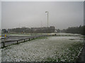
4
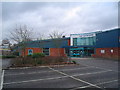
Hart Leisure Centre, Fleet
Normally far busier than this New Years Day photo suggests, this is Hart's local leisure centre which provides swimming, squash and other leisure facilities for the local community.
Image: © MickofFleet
Taken: 1 Jan 2006
0.08 miles
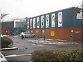
5
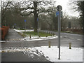
Entrance to Hart Leisure Centre
Hitches Lane.
Image: © Fernweh
Taken: 6 Feb 2012
0.08 miles
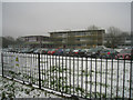
6

Fleet, Hampshire
Entrance to Hart Leisure Centre, in the north of the square.
Image: © Brendan and Ruth McCartney
Taken: 27 Jan 2011
0.09 miles
7
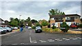
Bin day in Calthorpe Park
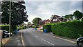
Tavistock Road is a long windy residential road.
Image: © James Emmans
Taken: 22 Jul 2022
0.10 miles
8
Shaldon Way
Semidetached houses in Calthorpe Park, a suburb of Fleet.
Image: © James Emmans
Taken: 22 Jul 2022
0.10 miles