IMAGES TAKEN NEAR TO
Bluebell Walk, FLEET, GU51 4ST
Introduction
This page details the photographs taken nearby to Bluebell Walk, GU51 4ST by members of the Geograph project.
The Geograph project started in 2005 with the aim of publishing, organising and preserving representative images for every square kilometre of Great Britain, Ireland and the Isle of Man.

There are currently over 7.5m images from over14,400 individuals and you can help contribute to the project by visiting https://www.geograph.org.uk
Image Map
Images are licensed for reuse under creativecommons.org/licenses/by-sa/2.0
Notes
- Clicking on the map will re-center to the selected point.
- The higher the marker number, the further away the image location is from the centre of the postcode.
Image Listing (77 Images Found)
Images are licensed for reuse under creativecommons.org/licenses/by-sa/2.0
Image
Details
Distance
1
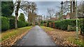
Waverley Avenue
Leafy private road with detached houses.
Image: © James Emmans
Taken: 13 Dec 2021
0.09 miles
3
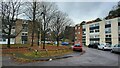
Nursery on Fleet Road
This Georgian style house, although probably built in the 20th century, is now a children's nursery school.
Image: © Graham Horn
Taken: 10 Mar 2011
0.14 miles
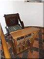
4
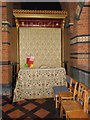
A Fleeting visit to All Saints': devotional area
Image: © Basher Eyre
Taken: 4 May 2012
0.14 miles
5
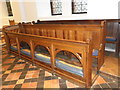
A Fleeting visit to All Saints': choir stalls
Image: © Basher Eyre
Taken: 4 May 2012
0.14 miles
7
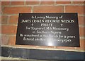
A Fleeting visit to All Saints': memorial (b)
Image: © Basher Eyre
Taken: 4 May 2012
0.14 miles
8

A Fleeting visit to All Saints': Mothers' Union banner (a)
Image: © Basher Eyre
Taken: 4 May 2012
0.14 miles
9
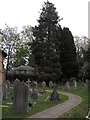
A Fleeting visit to All Saints': church path
Image: © Basher Eyre
Taken: 4 May 2012
0.14 miles
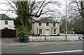
10
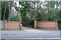
Entrance on Fleet Road
Despite the built up area, there are still some larger houses hidden back from the road, shielded by the conifers that grow successfully on this sandy heathland terrain.
Image: © Graham Horn
Taken: 10 Mar 2011
0.14 miles