IMAGES TAKEN NEAR TO
Orchard Fields, FLEET, GU51 4SN
Introduction
This page details the photographs taken nearby to Orchard Fields, GU51 4SN by members of the Geograph project.
The Geograph project started in 2005 with the aim of publishing, organising and preserving representative images for every square kilometre of Great Britain, Ireland and the Isle of Man.

There are currently over 7.5m images from over14,400 individuals and you can help contribute to the project by visiting https://www.geograph.org.uk
Image Map
Images are licensed for reuse under creativecommons.org/licenses/by-sa/2.0
Notes
- Clicking on the map will re-center to the selected point.
- The higher the marker number, the further away the image location is from the centre of the postcode.
Image Listing (121 Images Found)
Images are licensed for reuse under creativecommons.org/licenses/by-sa/2.0
Image
Details
Distance
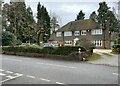
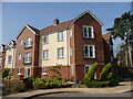
2
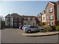
Apartment Block, Fleet, Hampshire
Image: © Christine Matthews
Taken: 14 Mar 2014
0.06 miles
3
Branksomewood Road, Fleet, Hampshire
Image: © Christine Matthews
Taken: 14 Mar 2014
0.06 miles
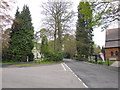
4
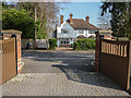
Looking from Church Road into Glebe Court
Image: © Basher Eyre
Taken: 4 May 2012
0.08 miles
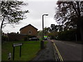
7
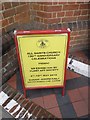
A Fleeting visit to All Saints': 150th anniversary celebration board
Image: © Basher Eyre
Taken: 4 May 2012
0.09 miles
8
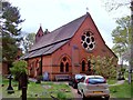
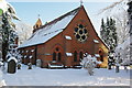
All Saints Church, Fleet
The building of All Saints Church was commissioned by Mr Charles Edward Lefroy as a memorial to his wife, Janet, at the cost of £3,323.For further details refer to picture Image
Image: © Len Williams
Taken: 19 Apr 2014
0.09 miles
9
Apartment Block, Fleet, Hampshire
Image: © Christine Matthews
Taken: 14 Mar 2014
0.09 miles
10
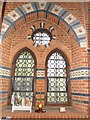
A Fleeting visit to All Saints': south facing window
Image: © Basher Eyre
Taken: 4 May 2012
0.09 miles