IMAGES TAKEN NEAR TO
Elvetham Road, FLEET, GU51 4HH
Introduction
This page details the photographs taken nearby to Elvetham Road, GU51 4HH by members of the Geograph project.
The Geograph project started in 2005 with the aim of publishing, organising and preserving representative images for every square kilometre of Great Britain, Ireland and the Isle of Man.

There are currently over 7.5m images from over14,400 individuals and you can help contribute to the project by visiting https://www.geograph.org.uk
Image Map
Images are licensed for reuse under creativecommons.org/licenses/by-sa/2.0
Notes
- Clicking on the map will re-center to the selected point.
- The higher the marker number, the further away the image location is from the centre of the postcode.
Image Listing (110 Images Found)
Images are licensed for reuse under creativecommons.org/licenses/by-sa/2.0
Image
Details
Distance
7
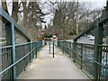
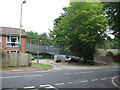
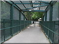
Footbridge ramp
From Elvetham Heath housing development to Fleet, crossing the main railway line between London and Southampton.
Image: © Mr Ignavy
Taken: 4 Mar 2024
0.03 miles