IMAGES TAKEN NEAR TO
Clarence Road, FLEET, GU51 3RR
Introduction
This page details the photographs taken nearby to Clarence Road, GU51 3RR by members of the Geograph project.
The Geograph project started in 2005 with the aim of publishing, organising and preserving representative images for every square kilometre of Great Britain, Ireland and the Isle of Man.

There are currently over 7.5m images from over14,400 individuals and you can help contribute to the project by visiting https://www.geograph.org.uk
Image Map
Images are licensed for reuse under creativecommons.org/licenses/by-sa/2.0
Notes
- Clicking on the map will re-center to the selected point.
- The higher the marker number, the further away the image location is from the centre of the postcode.
Image Listing (130 Images Found)
Images are licensed for reuse under creativecommons.org/licenses/by-sa/2.0
Image
Details
Distance

8
Bulldog - PC.Com
Albert Street / Upper Street.
Image: © Fernweh
Taken: 6 Feb 2012
0.08 miles
10
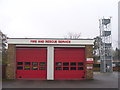
Fleet - Fire and Rescue Service
Modern fire station and look-out tower on Connaught Road, close to the village centre.
http://en.wikipedia.org/wiki/Fleet,_Hampshire
Image: © Colin Smith
Taken: 9 Mar 2013
0.09 miles