IMAGES TAKEN NEAR TO
Albany Road, FLEET, GU51 3PU
Introduction
This page details the photographs taken nearby to Albany Road, GU51 3PU by members of the Geograph project.
The Geograph project started in 2005 with the aim of publishing, organising and preserving representative images for every square kilometre of Great Britain, Ireland and the Isle of Man.

There are currently over 7.5m images from over14,400 individuals and you can help contribute to the project by visiting https://www.geograph.org.uk
Image Map
Images are licensed for reuse under creativecommons.org/licenses/by-sa/2.0
Notes
- Clicking on the map will re-center to the selected point.
- The higher the marker number, the further away the image location is from the centre of the postcode.
Image Listing (25 Images Found)
Images are licensed for reuse under creativecommons.org/licenses/by-sa/2.0
Image
Details
Distance
1
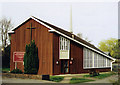
St Philip & St James, Fleet
Built in 1966 in the area known as Pondtail.
Image: © Michael FORD
Taken: Unknown
0.11 miles

4
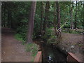
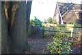
Oakley Park, Fleet
This square is almost entirely made up of suburban streets and houses. In the middle of this is Oakley Park, which consists of a large open field, and a wooded area with streams and a pond.
Image: © Darren Smith
Taken: 10 Jun 2005
0.16 miles
5
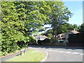
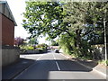
Montrose Close at the junction of Aldershot Road
Image: © David Howard
Taken: 7 Jun 2015
0.17 miles
6
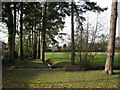
Oakley Park
The start of Oakley Park which has woodland, streams and ponds as well as recreation areas.
Image: © don cload
Taken: 31 Jan 2010
0.18 miles
8
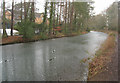
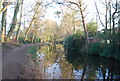
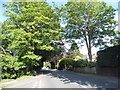
Basingstoke Canal by the Aldershot Road
Fleet.
Image: © Fernweh
Taken: 6 Feb 2012
0.19 miles