IMAGES TAKEN NEAR TO
Heathland Close, FLEET, GU51 3FH
Introduction
This page details the photographs taken nearby to Heathland Close, GU51 3FH by members of the Geograph project.
The Geograph project started in 2005 with the aim of publishing, organising and preserving representative images for every square kilometre of Great Britain, Ireland and the Isle of Man.

There are currently over 7.5m images from over14,400 individuals and you can help contribute to the project by visiting https://www.geograph.org.uk
Image Map
Images are licensed for reuse under creativecommons.org/licenses/by-sa/2.0
Notes
- Clicking on the map will re-center to the selected point.
- The higher the marker number, the further away the image location is from the centre of the postcode.
Image Listing (7 Images Found)
Images are licensed for reuse under creativecommons.org/licenses/by-sa/2.0
Image
Details
Distance
1
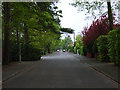
Wood Lane, Fleet
A residential road on the edge of Fleet where the town meets the heath, wood and marshland around Fleet Pond.
Image: © Andrew Smith
Taken: 14 May 2006
0.06 miles
2
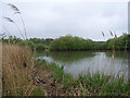
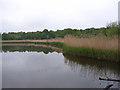
Fleet Pond
The marshy shoreline at Fugelmere Bay.
Image: © Andrew Smith
Taken: 14 May 2006
0.19 miles
3
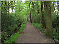
Footpath near Fleet Pond
Path alongside Gelvert Stream heading away from the pond.
Image: © Andrew Smith
Taken: 14 May 2006
0.20 miles
4
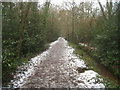
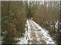
Path through Gelvert Glade
Fleet Pond Nature Reserve.
Image: © Fernweh
Taken: 6 Feb 2012
0.24 miles
5
Fleet Pond
From Sand Bay where Gelvert Stream flows in.
Image: © Andrew Smith
Taken: 14 May 2006
0.24 miles
6
Walkway through The Spreads
Fleet Pond Nature Reserve.
Image: © Fernweh
Taken: 6 Feb 2012
0.25 miles
7
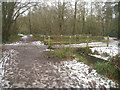
Footbridge across Gelvert Stream
The stream flows northwards into an area of Fleet Pond known as 'The Spreads'.
Image: © Fernweh
Taken: 6 Feb 2012
0.25 miles