IMAGES TAKEN NEAR TO
Kings Road, FLEET, GU51 3DR
Introduction
This page details the photographs taken nearby to Kings Road, GU51 3DR by members of the Geograph project.
The Geograph project started in 2005 with the aim of publishing, organising and preserving representative images for every square kilometre of Great Britain, Ireland and the Isle of Man.

There are currently over 7.5m images from over14,400 individuals and you can help contribute to the project by visiting https://www.geograph.org.uk
Image Map
Images are licensed for reuse under creativecommons.org/licenses/by-sa/2.0
Notes
- Clicking on the map will re-center to the selected point.
- The higher the marker number, the further away the image location is from the centre of the postcode.
Image Listing (39 Images Found)
Images are licensed for reuse under creativecommons.org/licenses/by-sa/2.0
Image
Details
Distance
1
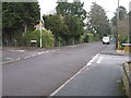
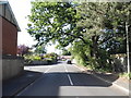
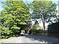
Guildford Road/Alton Road crossroads, Fleet
Image: © Richard Rogerson
Taken: 6 Feb 2010
0.11 miles
2
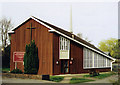
St Philip & St James, Fleet
Built in 1966 in the area known as Pondtail.
Image: © Michael FORD
Taken: Unknown
0.16 miles
3
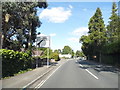
Aldershot Road, Fleet
There are two Aldershot Roads in Fleet, not unusual in Britain but highly confusing for post and vehicles.
Image: © David Howard
Taken: 7 Jun 2015
0.16 miles
4
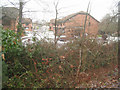
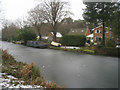
St Michaels Close
As seen from the Basingstoke Canal towpath.
Image: © Fernweh
Taken: 6 Feb 2012
0.17 miles
6
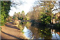
Basingstoke Canal - Fleet
A short distance west of Pondtail bridge.
Image: © Fernweh
Taken: 6 Feb 2012
0.19 miles
10
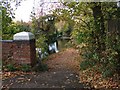
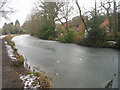
Footpath leading from Pondtail Road bridge down to Basingstoke Canal
Image: © Katherine Rusbridge
Taken: 7 Nov 2008
0.20 miles