IMAGES TAKEN NEAR TO
Saddleback Way, FLEET, GU51 2US
Introduction
This page details the photographs taken nearby to Saddleback Way, GU51 2US by members of the Geograph project.
The Geograph project started in 2005 with the aim of publishing, organising and preserving representative images for every square kilometre of Great Britain, Ireland and the Isle of Man.

There are currently over 7.5m images from over14,400 individuals and you can help contribute to the project by visiting https://www.geograph.org.uk
Image Map
Images are licensed for reuse under creativecommons.org/licenses/by-sa/2.0
Notes
- Clicking on the map will re-center to the selected point.
- The higher the marker number, the further away the image location is from the centre of the postcode.
Image Listing (24 Images Found)
Images are licensed for reuse under creativecommons.org/licenses/by-sa/2.0
Image
Details
Distance

3
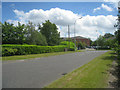
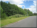
Open space by Angora Way, Ancells Farm
A footpath runs through the Ancells Farm estate, with a wide open space alongside it.
Image: © Rich Tea
Taken: 11 Mar 2009
0.12 miles
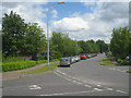

9
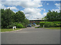
Fleet: B3013 Minley Road, Elvetham Heath Way & Ancells Road roundabout (2)
The Ordnance Survey 156000 Northing grid line bisects the roundabout, to the right here, so Image] is in the grid square to the north.
Image: © Nigel Cox
Taken: 31 Jan 2016
0.14 miles
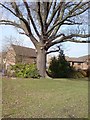
10
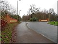
Harvest Crescent, Ancells Park, Fleet
Image: © Stacey Harris
Taken: 6 Jul 2009
0.14 miles