IMAGES TAKEN NEAR TO
Rye Close, FLEET, GU51 2UH
Introduction
This page details the photographs taken nearby to Rye Close, GU51 2UH by members of the Geograph project.
The Geograph project started in 2005 with the aim of publishing, organising and preserving representative images for every square kilometre of Great Britain, Ireland and the Isle of Man.

There are currently over 7.5m images from over14,400 individuals and you can help contribute to the project by visiting https://www.geograph.org.uk
Image Map
Images are licensed for reuse under creativecommons.org/licenses/by-sa/2.0
Notes
- Clicking on the map will re-center to the selected point.
- The higher the marker number, the further away the image location is from the centre of the postcode.
Image Listing (36 Images Found)
Images are licensed for reuse under creativecommons.org/licenses/by-sa/2.0
Image
Details
Distance
3
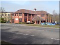
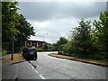
Offices, Ancells Business Park, Fleet
By Ancells Road
Image: © Rich Tea
Taken: 11 Mar 2009
0.08 miles

6
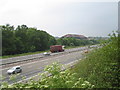
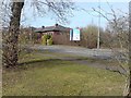
M3 Motorway and Ancells Business Park, Fleet
This square has the M3 motorway passing through it, but is otherwise made up of fields and woods used for MOD training. Ancells Business Park occupies part of the SW section, this photo shows some of its buildings in the distance, taken from the disused bridge crossing the motorway.
Image: © Darren Smith
Taken: 10 Jun 2005
0.11 miles
8
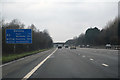
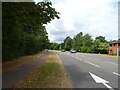
Hart : M3 Motorway
The M3 Motorway between Junction 4A (Fleet) and Junction 5 (Hook Interchange).
Image: © Lewis Clarke
Taken: 25 Mar 2018
0.12 miles

10
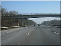
M3 north of Fleet
The footbridge marks the limit of MOD 'managed access' land.
Image: © Fernweh
Taken: 11 Feb 2012
0.12 miles