IMAGES TAKEN NEAR TO
Shetland Way, FLEET, GU51 2UD
Introduction
This page details the photographs taken nearby to Shetland Way, GU51 2UD by members of the Geograph project.
The Geograph project started in 2005 with the aim of publishing, organising and preserving representative images for every square kilometre of Great Britain, Ireland and the Isle of Man.

There are currently over 7.5m images from over14,400 individuals and you can help contribute to the project by visiting https://www.geograph.org.uk
Image Map
Images are licensed for reuse under creativecommons.org/licenses/by-sa/2.0
Notes
- Clicking on the map will re-center to the selected point.
- The higher the marker number, the further away the image location is from the centre of the postcode.
Image Listing (35 Images Found)
Images are licensed for reuse under creativecommons.org/licenses/by-sa/2.0
Image
Details
Distance
1
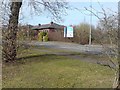
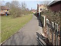
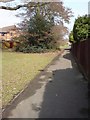
Open space by Angora Way, Ancells Farm
A footpath runs through the Ancells Farm estate, with a wide open space alongside it.
Image: © Rich Tea
Taken: 11 Mar 2009
0.06 miles
2
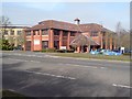
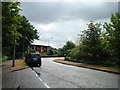
Offices, Ancells Business Park, Fleet
By Ancells Road
Image: © Rich Tea
Taken: 11 Mar 2009
0.06 miles