IMAGES TAKEN NEAR TO
Hugh De Port Lane, FLEET, GU51 1HT
Introduction
This page details the photographs taken nearby to Hugh De Port Lane, GU51 1HT by members of the Geograph project.
The Geograph project started in 2005 with the aim of publishing, organising and preserving representative images for every square kilometre of Great Britain, Ireland and the Isle of Man.

There are currently over 7.5m images from over14,400 individuals and you can help contribute to the project by visiting https://www.geograph.org.uk
Image Map
Images are licensed for reuse under creativecommons.org/licenses/by-sa/2.0
Notes
- Clicking on the map will re-center to the selected point.
- The higher the marker number, the further away the image location is from the centre of the postcode.
Image Listing (64 Images Found)
Images are licensed for reuse under creativecommons.org/licenses/by-sa/2.0
Image
Details
Distance
1
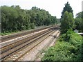
There goes the woodland
Rear view of properties in King John Street.
Image: © Mr Ignavy
Taken: 28 Jul 2008
0.10 miles
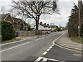
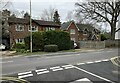
2
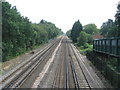
Is it the up or down ramp?
Looking towards King John Street homes.
Image: © Mr Ignavy
Taken: 28 Jul 2008
0.10 miles
4
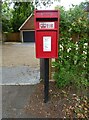
Elizabeth II postbox on Elvetham Road, Fleet
Postbox No. GU51 79.
Image: © JThomas
Taken: 27 Jul 2022
0.11 miles
9
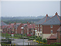
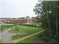
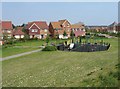
Elvetham Heath
Newly built (and still being built) housing estate between the railway and the motorway, to the north of Fleet.
Image: © Andrew Smith
Taken: 14 May 2006
0.14 miles