IMAGES TAKEN NEAR TO
Lasham Road, FLEET, GU51 1HF
Introduction
This page details the photographs taken nearby to Lasham Road, GU51 1HF by members of the Geograph project.
The Geograph project started in 2005 with the aim of publishing, organising and preserving representative images for every square kilometre of Great Britain, Ireland and the Isle of Man.

There are currently over 7.5m images from over14,400 individuals and you can help contribute to the project by visiting https://www.geograph.org.uk
Image Map
Images are licensed for reuse under creativecommons.org/licenses/by-sa/2.0
Notes
- Clicking on the map will re-center to the selected point.
- The higher the marker number, the further away the image location is from the centre of the postcode.
Image Listing (78 Images Found)
Images are licensed for reuse under creativecommons.org/licenses/by-sa/2.0
Image
Details
Distance
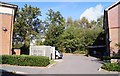
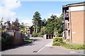
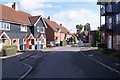
1
Houses in Lasham Road - rear view
The trees in the background mark the M3.
Image: © Fernweh
Taken: 1 Oct 2014
0.01 miles
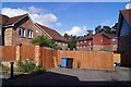
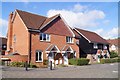
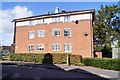
2
Houses in Lasham Way
Beyond the last houses runs the M3 motorway.
Image: © Fernweh
Taken: 17 Oct 2014
0.02 miles
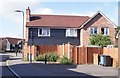
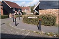
9
Only two dishes!
Affordable housing in Lyndhurst Road, right next to the M3.
Image: © Fernweh
Taken: 1 Oct 2014
0.04 miles