IMAGES TAKEN NEAR TO
Guildford Road, GUILDFORD, GU5 0RT
Introduction
This page details the photographs taken nearby to Guildford Road, GU5 0RT by members of the Geograph project.
The Geograph project started in 2005 with the aim of publishing, organising and preserving representative images for every square kilometre of Great Britain, Ireland and the Isle of Man.

There are currently over 7.5m images from over14,400 individuals and you can help contribute to the project by visiting https://www.geograph.org.uk
Image Map
Images are licensed for reuse under creativecommons.org/licenses/by-sa/2.0
Notes
- Clicking on the map will re-center to the selected point.
- The higher the marker number, the further away the image location is from the centre of the postcode.
Image Listing (6 Images Found)
Images are licensed for reuse under creativecommons.org/licenses/by-sa/2.0
Image
Details
Distance
1
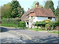
Dodman's Cottage
There's a Surrey County Council plaque on this house to say it's a building of special interest
Image: © Andrew Longton
Taken: 4 May 2006
0.03 miles
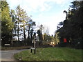
3
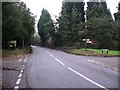
Crossroads near Shamley Green
The main road is the B2128 with Norley Lane on the right and Northcote Lane on the left.
Image: © Shazz
Taken: 15 Dec 2010
0.11 miles
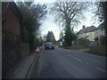
4
Norley Lane at the junction of Guildford Road
Image: © David Howard
Taken: 28 Feb 2016
0.11 miles
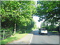
5
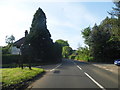
Guildford Road at the junction of Norley Lane
Image: © David Howard
Taken: 2 Jun 2013
0.12 miles