IMAGES TAKEN NEAR TO
Grantley Avenue, GUILDFORD, GU5 0QN
Introduction
This page details the photographs taken nearby to Grantley Avenue, GU5 0QN by members of the Geograph project.
The Geograph project started in 2005 with the aim of publishing, organising and preserving representative images for every square kilometre of Great Britain, Ireland and the Isle of Man.

There are currently over 7.5m images from over14,400 individuals and you can help contribute to the project by visiting https://www.geograph.org.uk
Image Map
Images are licensed for reuse under creativecommons.org/licenses/by-sa/2.0
Notes
- Clicking on the map will re-center to the selected point.
- The higher the marker number, the further away the image location is from the centre of the postcode.
Image Listing (3 Images Found)
Images are licensed for reuse under creativecommons.org/licenses/by-sa/2.0
Image
Details
Distance
1
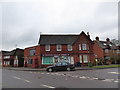
Wonersh Village Stores: early February 2017
Image: © Basher Eyre
Taken: 2 Feb 2017
0.15 miles
2
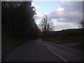
Cranleigh Road, Wonersh
The B2128 runs from Shalford in the north to Rudgwick.
Image: © David Howard
Taken: 26 Feb 2012
0.16 miles
3
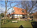
Nutwood House, Wonersh
Nutwood is where Rupert Bear comes from but I don't know if that was connected.
Image: © David Howard
Taken: 28 Feb 2016
0.24 miles