IMAGES TAKEN NEAR TO
Mellersh Hill Road, GUILDFORD, GU5 0QJ
Introduction
This page details the photographs taken nearby to Mellersh Hill Road, GU5 0QJ by members of the Geograph project.
The Geograph project started in 2005 with the aim of publishing, organising and preserving representative images for every square kilometre of Great Britain, Ireland and the Isle of Man.

There are currently over 7.5m images from over14,400 individuals and you can help contribute to the project by visiting https://www.geograph.org.uk
Image Map
Images are licensed for reuse under creativecommons.org/licenses/by-sa/2.0
Notes
- Clicking on the map will re-center to the selected point.
- The higher the marker number, the further away the image location is from the centre of the postcode.
Image Listing (8 Images Found)
Images are licensed for reuse under creativecommons.org/licenses/by-sa/2.0
Image
Details
Distance
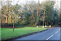
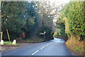
1
Cranleigh Road, Wonersh
The B2128 runs from Shalford in the north to Rudgwick.
Image: © David Howard
Taken: 26 Feb 2012
0.14 miles
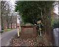
2
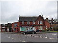
Wonersh Village Stores: early February 2017
Image: © Basher Eyre
Taken: 2 Feb 2017
0.19 miles
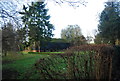
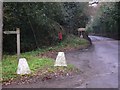
3
Entrance to St John's Seminary
This is at Wonersh and the road on the right is the B2128 (Cranleigh Road).
Image: © Shazz
Taken: 15 Dec 2010
0.20 miles
4
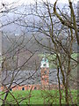
St John's Seminary
Seen through the trees from the path descending Barnett Hill. The seminary was established in 1891 and trains priests for the Archdioceses of Southwark and Arundel & Brighton.
Image: © Colin Smith
Taken: 20 Jan 2008
0.21 miles
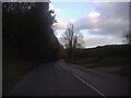
6
Footpath sign just south of Wonersh
The road is the B2128.
Image: © Shazz
Taken: 15 Dec 2010
0.23 miles