IMAGES TAKEN NEAR TO
Wonersh Common, Wonersh, GUILDFORD, GU5 0PL
Introduction
This page details the photographs taken nearby to GU5 0PL by members of the Geograph project.
The Geograph project started in 2005 with the aim of publishing, organising and preserving representative images for every square kilometre of Great Britain, Ireland and the Isle of Man.

There are currently over 7.5m images from over14,400 individuals and you can help contribute to the project by visiting https://www.geograph.org.uk
Image Map
Images are licensed for reuse under creativecommons.org/licenses/by-sa/2.0
Notes
- Clicking on the map will re-center to the selected point.
- The higher the marker number, the further away the image location is from the centre of the postcode.
Image Listing (30 Images Found)
Images are licensed for reuse under creativecommons.org/licenses/by-sa/2.0
Image
Details
Distance

2
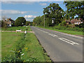
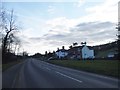
King's Road, Wonersh
Looking north along King's Road as it leaves Wonersh village.
Image: © Alan Hunt
Taken: 2 Sep 2014
0.03 miles
3
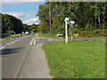
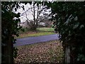
Blackheath Lane junction
The junction of Blackheath Lane with King's Road just north of Wonersh village.
Image: © Alan Hunt
Taken: 2 Sep 2014
0.10 miles
4
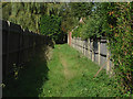
Footpath, Wonersh
The footpath from The Street to King's Road.
Image: © Alan Hunt
Taken: 2 Sep 2014
0.10 miles
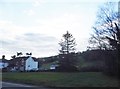
5
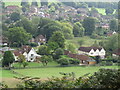
Wonersh - From Chinthurst Hill
Modern residential area to the north of Wonersh village centre - one of the prospects from heavily wooded Chinthurst Hill.
www.surreywildlifetrust.org
Image: © Colin Smith
Taken: 10 Sep 2022
0.10 miles
6
Footpath arrives at Blackheath Lane north of Wonersh
Image: © Shazz
Taken: 1 Feb 2011
0.13 miles
8
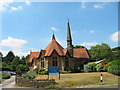
United Reformed Church, Wonersh, Surrey
Image: © Stuart and Fiona Jackson
Taken: 20 Jul 2005
0.13 miles
10
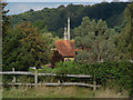
Wonersh United Reformed Church
The spire of the United Reformed Church from the footpath from The Street with the woodland covered Tangley Hill in the background.
Image: © Alan Hunt
Taken: 2 Sep 2014
0.15 miles