IMAGES TAKEN NEAR TO
Palmers Cross, GUILDFORD, GU5 0LL
Introduction
This page details the photographs taken nearby to Palmers Cross, GU5 0LL by members of the Geograph project.
The Geograph project started in 2005 with the aim of publishing, organising and preserving representative images for every square kilometre of Great Britain, Ireland and the Isle of Man.

There are currently over 7.5m images from over14,400 individuals and you can help contribute to the project by visiting https://www.geograph.org.uk
Image Map
Images are licensed for reuse under creativecommons.org/licenses/by-sa/2.0
Notes
- Clicking on the map will re-center to the selected point.
- The higher the marker number, the further away the image location is from the centre of the postcode.
Image Listing (13 Images Found)
Images are licensed for reuse under creativecommons.org/licenses/by-sa/2.0
Image
Details
Distance
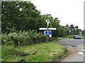
3
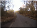
A281 at Palmers Cross
A junction beset with signs, not all essential to road safety.
Image: © Robin Webster
Taken: 3 Oct 2011
0.07 miles
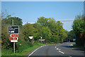
4
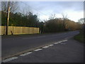
Horsham Road at Palmers Cross
The fence has recently been added around 2011
Image: © David Howard
Taken: 26 Feb 2012
0.08 miles
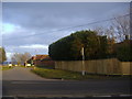
5
Horsham Road at Palmers Cross
The fence has been added recently around 2011
Image: © David Howard
Taken: 26 Feb 2012
0.08 miles
7
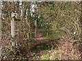
Footpath sign near Whipley Manor Farm
The footpath enters a small piece of woodland before reaching the A281.
Image: © Shazz
Taken: 24 Feb 2011
0.15 miles
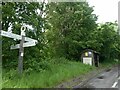
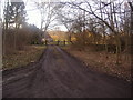
8
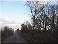
Thorncombe Street, Palmers Cross
The junction with Horsham Road can just be seen at the end
Image: © David Howard
Taken: 26 Feb 2012
0.15 miles
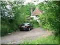
10
Entrance to house on Thorncombe Street
Image: © David Howard
Taken: 26 Feb 2012
0.17 miles