IMAGES TAKEN NEAR TO
Rushett Common, GUILDFORD, GU5 0LG
Introduction
This page details the photographs taken nearby to Rushett Common, GU5 0LG by members of the Geograph project.
The Geograph project started in 2005 with the aim of publishing, organising and preserving representative images for every square kilometre of Great Britain, Ireland and the Isle of Man.

There are currently over 7.5m images from over14,400 individuals and you can help contribute to the project by visiting https://www.geograph.org.uk
Image Map
Images are licensed for reuse under creativecommons.org/licenses/by-sa/2.0
Notes
- Clicking on the map will re-center to the selected point.
- The higher the marker number, the further away the image location is from the centre of the postcode.
Image Listing (32 Images Found)
Images are licensed for reuse under creativecommons.org/licenses/by-sa/2.0
Image
Details
Distance
1
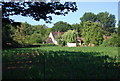
House seen across a field of Maize, Rushett Common
Image: © N Chadwick
Taken: 4 Jul 2010
0.04 miles
5

On the Wey South
Long distance path shared here with the Downs Link - both on the former trackbed of the Cranleigh to Guildford railway line. The remains of a section of the Wey & Arun Junction Canal is behind this sign, just over the embankment.
Image: © Colin Smith
Taken: 28 Dec 2008
0.09 miles
6
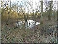
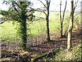
Pond on Rushett Common
For some reason this hasn't been included on the OS map
Image: © David Howard
Taken: 28 Feb 2016
0.10 miles
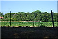
7
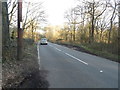
Rushett Common
The road name says this is the name of the road as well
Image: © David Howard
Taken: 28 Feb 2016
0.10 miles
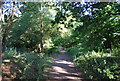
8
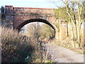
Former Railway Bridge by Rushett Farm
The bridge crosses the alignment of the former Guildford - Cranleigh - Horsham railway line. The old line is now a light surfaced long distance footpath - Downs Link and Wey South Path here.
Image: © Colin Smith
Taken: 28 Dec 2008
0.11 miles
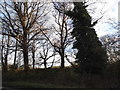
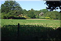
10
Rooks Hill Farm
Grassy fields of Wealden clay with the farm buildings in the distance. In the foreground, at the foot of the former railway embankment, is a small stream.
Image: © Colin Smith
Taken: 28 Dec 2008
0.12 miles