IMAGES TAKEN NEAR TO
Park Drive, GUILDFORD, GU5 0FA
Introduction
This page details the photographs taken nearby to Park Drive, GU5 0FA by members of the Geograph project.
The Geograph project started in 2005 with the aim of publishing, organising and preserving representative images for every square kilometre of Great Britain, Ireland and the Isle of Man.

There are currently over 7.5m images from over14,400 individuals and you can help contribute to the project by visiting https://www.geograph.org.uk
Image Map
Images are licensed for reuse under creativecommons.org/licenses/by-sa/2.0
Notes
- Clicking on the map will re-center to the selected point.
- The higher the marker number, the further away the image location is from the centre of the postcode.
Image Listing (50 Images Found)
Images are licensed for reuse under creativecommons.org/licenses/by-sa/2.0
Image
Details
Distance
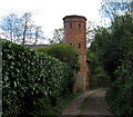
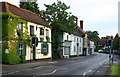
2
Mill Lane
Mews cottage with atmospheric old millstone and milkchurn on the quiet lane leading to Bramley Mill Pond.
Image: © Colin Smith
Taken: 17 Aug 2008
0.11 miles
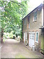
3
Bramley Mill
Worked by the Andrews family from 1851 to the early 1900s.
Image: © Clare
Taken: 5 May 2003
0.11 miles
4
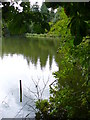
Pond in Bramley
Dammed tree-fringed pond by Mill Lane in Bramley. It is used by local anglers.
Image: © Colin Smith
Taken: 17 Aug 2008
0.11 miles
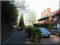
5
West side of Bramley High Street
Not changed much in 150 years
Image: © Eric Hill
Taken: 22 May 2006
0.13 miles
7
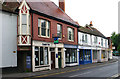
West side of Bramley High Street
Not changed much in 150 years!
Image: © Eric Hill
Taken: 22 May 2006
0.18 miles
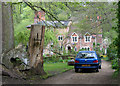
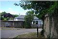
8
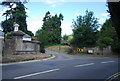
Park Drive off High St
Originally the drive to Bramley Court.
Image: © N Chadwick
Taken: 4 Jul 2010
0.18 miles
9
Lodge at the entrance to Bramley Court Park
Image: © N Chadwick
Taken: 4 Jul 2010
0.18 miles
