IMAGES TAKEN NEAR TO
Maiden Lane, GUILDFORD, GU5 0EZ
Introduction
This page details the photographs taken nearby to Maiden Lane, GU5 0EZ by members of the Geograph project.
The Geograph project started in 2005 with the aim of publishing, organising and preserving representative images for every square kilometre of Great Britain, Ireland and the Isle of Man.

There are currently over 7.5m images from over14,400 individuals and you can help contribute to the project by visiting https://www.geograph.org.uk
Image Map
Images are licensed for reuse under creativecommons.org/licenses/by-sa/2.0
Notes
- Clicking on the map will re-center to the selected point.
- The higher the marker number, the further away the image location is from the centre of the postcode.
Image Listing (78 Images Found)
Images are licensed for reuse under creativecommons.org/licenses/by-sa/2.0
Image
Details
Distance
1
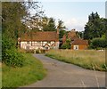
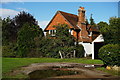
Cottage off Tannery Lane (2)
Partly timber-framed and of very higgledy-piggledy construction, probably dating back three or four centuries. The cottage overlooks a green to the east of the Guildford-Horsham road.
For another view, see: http://www.geograph.org.uk/photo/4136169
Image: © Stefan Czapski
Taken: 22 Aug 2014
0.06 miles
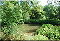
3

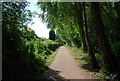
Former railway line
A stretch of the old Guildford to Horsham line, which was closed in 1965 and has been re-surfaced to serve as part of the Downs Link long-distance path. The easy railway gradients make this a handy cycle route. Apparently the local authority (Waverley) has resisted all proposed developments that might encroach upon the old track-bed - recognising that even local encroachment would compromise the alignment's availability for future transport purposes.
Image: © Stefan Czapski
Taken: 22 Aug 2014
0.07 miles
4
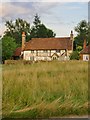
Cottage off Tannery Lane (1)
Set back some distance from the cricket green. The cottage is at least part timber-framed, no two windows are the same size (or shape), and the impression is of a structure that has developed in a higgledy-piggledy fashion over a period of centuries. It seems a shame to dismiss it as Image
Image shows a little more of the context.
Image: © Stefan Czapski
Taken: 22 Aug 2014
0.07 miles
6
Cottage Near Bramley, Surrey
Located just off the Horsham Road.
Image: © Peter Trimming
Taken: 11 Oct 2014
0.08 miles
7

Bramley cricket pitch
The village cricket pitch with the houses along Tannery Lane in the background.
Image: © Alan Hunt
Taken: 6 Sep 2014
0.08 miles

10
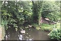
Site of old Railway Bridge
North of Bramley the old Downslink railway crossed the Wey and Arun Canal. The bridge is no longer there.
Image: © Chris Thomas-Atkin
Taken: 16 Jul 2017
0.09 miles