IMAGES TAKEN NEAR TO
Dorking Road, GUILDFORD, GU4 8RH
Introduction
This page details the photographs taken nearby to Dorking Road, GU4 8RH by members of the Geograph project.
The Geograph project started in 2005 with the aim of publishing, organising and preserving representative images for every square kilometre of Great Britain, Ireland and the Isle of Man.

There are currently over 7.5m images from over14,400 individuals and you can help contribute to the project by visiting https://www.geograph.org.uk
Image Map
Images are licensed for reuse under creativecommons.org/licenses/by-sa/2.0
Notes
- Clicking on the map will re-center to the selected point.
- The higher the marker number, the further away the image location is from the centre of the postcode.
Image Listing (103 Images Found)
Images are licensed for reuse under creativecommons.org/licenses/by-sa/2.0
Image
Details
Distance
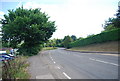
1
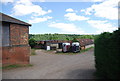
Lockner Farm seen from the North Downs Way
The nearest buildings are those of Lockner Farm, Chilworth. The photograph was taken from near St Martha's church.
Image: © Shazz
Taken: 11 Sep 2008
0.02 miles
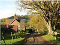
2
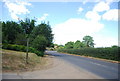
Chilworth - Lockner Farm
Quiet lane with St Martha's Hill on the skyline.
Image: © Colin Smith
Taken: 11 Feb 2018
0.02 miles
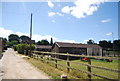
3
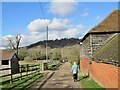
Horse boxes, Lockner Farm
The farm runs a stable.
Image: © N Chadwick
Taken: 4 Jul 2010
0.03 miles
5
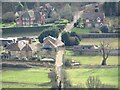
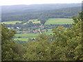
Chilworth - Lockner Farm
Farm in the Tillingbourne Valley at a crossroads on the Dorking Road - seen here from the top of St Martha's Hill.
Image: © Colin Smith
Taken: 2 Feb 2024
0.05 miles
8
Chilworth - Lockner Lodge
View from the railway bridge towards the main road, Chilworth-Albury. St Martha's Hill and Church are on the skyline.
Image: © Colin Smith
Taken: 12 Nov 2020
0.08 miles
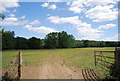
9
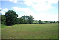
Vale of Holmesdale
A valley of Gault Clay between the Greensand to the south and the Chalk to the north.
Image: © N Chadwick
Taken: 4 Jul 2010
0.08 miles