IMAGES TAKEN NEAR TO
Tillingbourne Road, GUILDFORD, GU4 8EX
Introduction
This page details the photographs taken nearby to Tillingbourne Road, GU4 8EX by members of the Geograph project.
The Geograph project started in 2005 with the aim of publishing, organising and preserving representative images for every square kilometre of Great Britain, Ireland and the Isle of Man.

There are currently over 7.5m images from over14,400 individuals and you can help contribute to the project by visiting https://www.geograph.org.uk
Image Map (Loading...)


Getting Data...Please wait
Leaflet Map data © OpenStreetMap
Images are licensed for reuse under creativecommons.org/licenses/by-sa/2.0
Notes
- Clicking on the map will re-center to the selected point.
- The higher the marker number, the further away the image location is from the centre of the postcode.
Image Listing (106 Images Found)
Images are licensed for reuse under creativecommons.org/licenses/by-sa/2.0
Image
Details
Distance
1
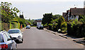
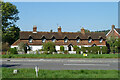
Tillingbourne Road, Shalford
The Tilling Bourne is a stream which runs closeby and later joins the River Wey
Image: © Kevin Gordon
Taken: 24 May 2009
0.02 miles

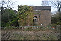
6
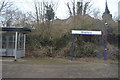
Foster's Row, Shalford
A grade II listed building, 1833.
Image: © Robin Webster
Taken: 3 Oct 2011
0.14 miles
8
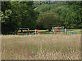
Shalford Common, play area
The children's play area on Shalford Common.
Image: © Alan Hunt
Taken: 14 Jul 2014
0.15 miles
10
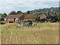
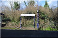
Shalford Common
The houses on the edge of Shalford Common with Guildford's Quarry Hill in the background.
Image: © Alan Hunt
Taken: 14 Jul 2014
0.15 miles