IMAGES TAKEN NEAR TO
Orchard Road, GUILDFORD, GU4 8ER
Introduction
This page details the photographs taken nearby to Orchard Road, GU4 8ER by members of the Geograph project.
The Geograph project started in 2005 with the aim of publishing, organising and preserving representative images for every square kilometre of Great Britain, Ireland and the Isle of Man.

There are currently over 7.5m images from over14,400 individuals and you can help contribute to the project by visiting https://www.geograph.org.uk
Image Map
Images are licensed for reuse under creativecommons.org/licenses/by-sa/2.0
Notes
- Clicking on the map will re-center to the selected point.
- The higher the marker number, the further away the image location is from the centre of the postcode.
Image Listing (172 Images Found)
Images are licensed for reuse under creativecommons.org/licenses/by-sa/2.0
Image
Details
Distance
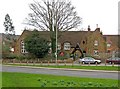
1
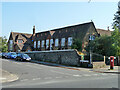
Infants School, Shalford
An 1855 grade II listed building.
Image: © Robin Webster
Taken: 3 Oct 2011
0.08 miles
2
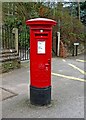
George V postbox, The Street, Shalford
The postbox which dates from the period 1910-1936, is in The Street, near the junction with Tillingbourne Road, and Station Row. See:- Image
Postbox number:- GU4 118. Post code:- GU4 8**. Last collection:- 5.30 p.m. Monday to Friday, 12 noon Saturday.
Image: © P L Chadwick
Taken: 10 Mar 2011
0.09 miles
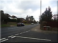
3
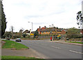
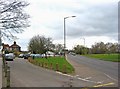
The junction of The Street, Tillingbourne Road and Station Row, Shalford
The road in the foreground is The Street, which is part of the A281. To the left of the postbox is Tillingbourne Road, and to the right of it is Station Row.
The postbox can be seen close-up in this view:- Image
Image: © P L Chadwick
Taken: 10 Mar 2011
0.09 miles
4
Part of Infants School, Shalford
An 1855 grade II listed building.
Image: © Robin Webster
Taken: 3 Oct 2011
0.09 miles
5
Shalford Infant School, Station Row, Shalford
The school extends a long way back, and also has a frontage to Tillingbourne Road.
Image: © P L Chadwick
Taken: 10 Mar 2011
0.09 miles
7
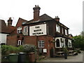
Shalford - The Queen Victoria
A popular village pub beside Shalford Railway Station.
Image: © Colin Smith
Taken: 29 Apr 2022
0.10 miles
8
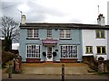
Pewleys, Richmond House, Station Row, Shalford
Pewleys are a firm of estate agents, who have been in business for about thirty years. Station Row is not the same road as Station Road, which is the other side of the railway line.
Image: © P L Chadwick
Taken: 10 Mar 2011
0.11 miles
9
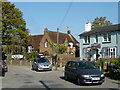
Station Row and The Street (A281), Shalford
On the left is Station Row, with the Queen Victoria pub in the distance. On the right is The Street, which is part of the A281. After crossing the railway line, the name changes to Horsham Road.
Image: © P L Chadwick
Taken: 10 Mar 2011
0.11 miles
10
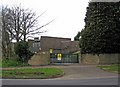
Electricity substation, The Street (A281), Shalford
A large electricity substation, with plenty of notices about the danger of death to trespassers.
Image: © P L Chadwick
Taken: 10 Mar 2011
0.11 miles